
Scatterted showers likely over Chennai
🌪️ CYCLONE UPDATE | BAY OF BENGAL
A tropical cyclone has developed over the South Central Bay of Bengal and is expected to intensify further over the next 24–48 hours. The system is likely to be named Murasu by IMD soon.
🌀 SYSTEM TRACK & INTENSITY
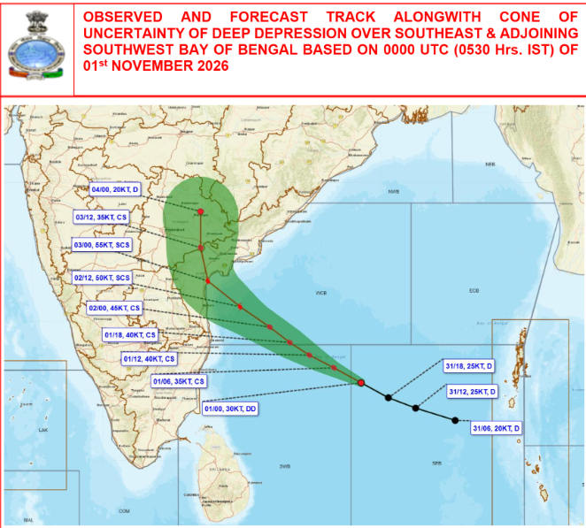
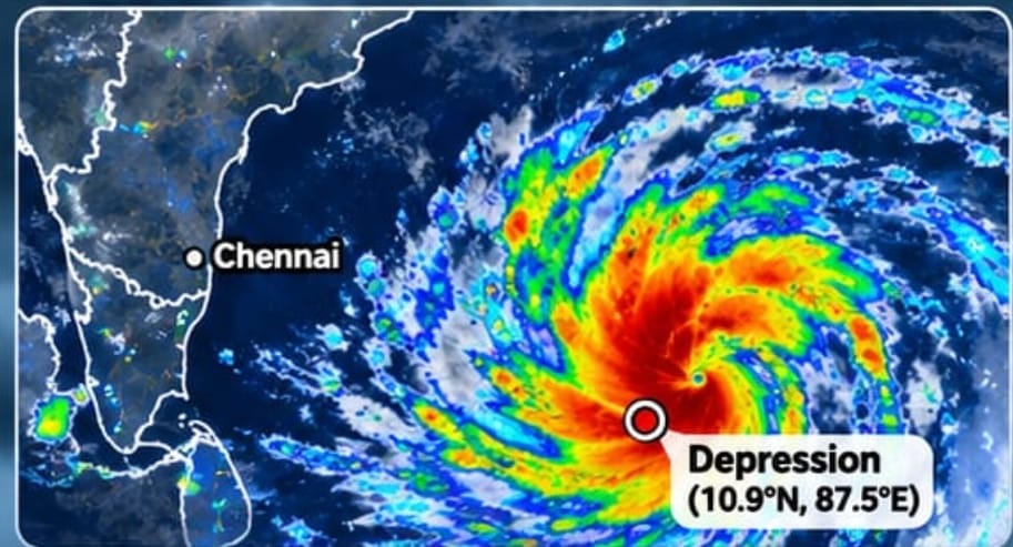
According to the latest IMD bulletin, the depression was located near 10.9°N, 87.5°E, approximately 830 km east-southeast of Chennai, at 11:30 PM IST on 31 October.
The system is moving west-northwestwards and is expected to intensify into a severe cyclonic storm over the west-central Bay of Bengal on 2 November.
The current IMD forecast indicates that the system will approach the South Andhra Pradesh coast and cross between Nellore and Narsapur by the morning of 3 November, with sustained winds of 100–110 km/h, gusting to 120 km/h, at landfall.
The northwestward movement is likely to be influenced by the ridge positioning to the north of the system.
🌧️ WHAT ABOUT CHENNAI?
The impact on Chennai and its surrounding districts will largely depend on how close the cyclone approaches the Tamil Nadu coast before recurving or continuing towards Andhra Pradesh.
Based on the current track scenario, here’s what we can expect:
📍 Tonight (1 November):
Light to moderate rainfall is possible across Chennai and neighbouring districts.
📍 Monday, 2 November:
Rainfall activity could increase from the afternoon into the night. Some locations may experience isolated heavy spells, while other areas could receive only light to moderate rainfall.
⚠️ Rainfall distribution: Don’t expect uniform, widespread rainfall across Chennai. The activity is more likely to be scattered and highly dependent on the position of the cyclone and the movement of its outer rainbands.
💨 WIND FORECAST FOR CHENNAI
As the system approaches its closest point to Chennai before moving towards Andhra Pradesh, surface winds could strengthen.
- Sustained winds: Around 25–40 km/h in stronger spells.
- Gusts: Potentially reaching 50–55 km/h in exposed locations, depending on the cyclone’s proximity.
These are preliminary expectations for Chennai, not official IMD wind warnings. The actual wind strength will depend on the cyclone’s final track and intensity.
📊 OUR TAKE :
The main area of concern remains South Andhra Pradesh, where the system is forecast to make landfall as a severe cyclonic storm.
For Chennai, the next 24–36 hours will be crucial. Even a relatively small shift in the cyclone’s track could change the rainfall distribution and wind intensity across North Tamil Nadu.
For now, Chennai can expect a spell of intermittent rain, with the possibility of isolated heavy showers on Monday. Whether the city receives more significant rainfall will depend on how close the cyclone tracks to the coast.